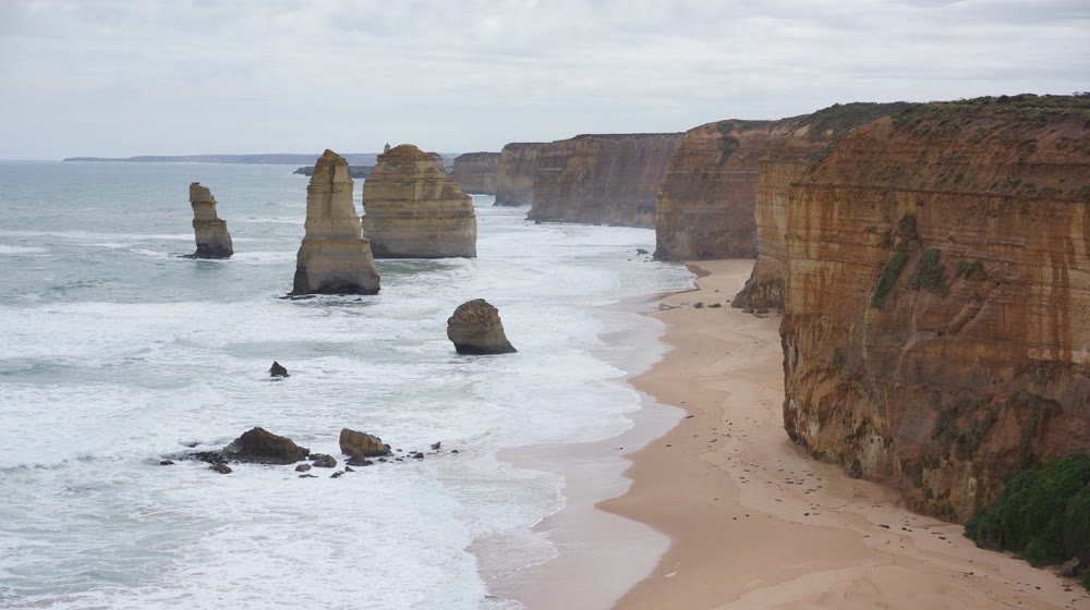
Australia’s most famous drive, on your own wheels. The road itself was cut by hand by returned soldiers as a war memorial, and the guide tells it place by place: the surf coast at Torquay and Bells Beach, the lighthouses, Lorne and the koalas of Kennett River, the rainforest of the Otways, then the Twelve Apostles, Loch Ard Gorge and the arches of the Shipwreck Coast.
At every stop it tells you where to park and how far to walk. Home is inland through Colac, and the podcast keeps you company on the long stretches.
Every place on the map
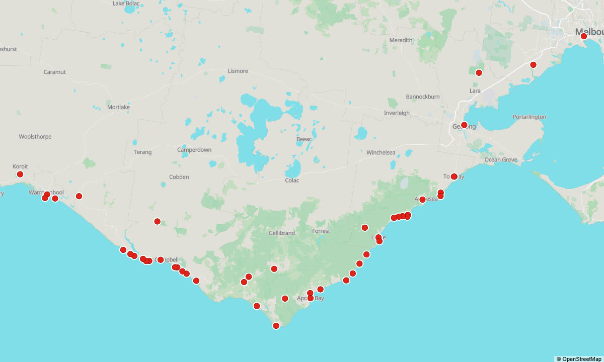
Each red dot is a place with its own story. The story starts by itself when you reach it — on foot, by bike or by car.
All 48 places in this guide
Here is every place the guide tells you about, with the first line of its story:
- West Gate Bridge — The day's first story begins on the biggest structure of the trip.
- Werribee Park Mansion — A few minutes off the freeway stands one of the grandest houses ever built in Victoria: a sixty-room Italianate mansion with a tower, built between 1874 and 1877 for two Scottish…
- Stone statues, You Yangs — The You Yangs. This granite ridge rises more than three hundred metres out of the flat volcanic plain between Melbourne and Geelong.
- Geelong Waterfront — Geelong is Victoria's second city, home to close to three hundred thousand people, and for most of its history it has faced the water.
- Australian National Surfing Museum — Torquay calls itself Surf City, and this building is a good part of the reason.
- Torquay, start of the Great Ocean Road — Torquay. This is where the Great Ocean Road begins. From here it runs about two hundred and forty kilometres along the coast to Allansford, near Warrnambool, and since 2011 it has been on Australia's National Heritage…
- Bells Beach — To the Wadawurrung this place is Djarrak, a name that describes the shape of the cliffs around it.
- Point Addis — This headland is the heart of the Point Addis Marine National Park, declared in 2002: about ten kilometres of coast from the eastern end of Bells Beach to near Anglesea, reaching three nautical miles out to sea.
- Anglesea and the kangaroos on the golf course — Anglesea. The town began as Swampy Creek. When the township was laid out in 1884 it became Anglesea River, after the island of Anglesey off the coast of Wales.
- Aireys Inlet — The town is named after John Airey, who settled here in 1842.
- Split Point Lighthouse — The White Queen, as she is known locally: a thirty-four-metre tower of concrete rendered with cement, white, with a red roof on the lantern, built and first lit in 1891 on a headland once called…
- Fairhaven — The beach here is more than six kilometres of open surf, the longest beach on the Great Ocean Road.
- Moggs Creek Lookout — The ridge above the mouth of Moggs Creek is Spion Kop, the most popular coastal hang-gliding site in Victoria.
- Great Ocean Road Memorial Arch — Great Ocean Road Memorial Arch, Eastern View. The road you are driving on is a war memorial, the largest in the world, and this timber arch is where it says so.
- Lorne — The best-loved seaside town on this coast, and for more than a hundred and fifty years the place Melbourne families have come to on holiday, even when it was hard to reach.
- Erskine Falls — A side trip of about nine kilometres from Lorne, up into the forest of the Otways, to the best-known waterfall on this coast.
- Teddy's Lookout — One of the most photographed views on the Great Ocean Road, the road swinging in tight curves around the cliffs above the mouth of the St George River, is taken from this hilltop on the southern edge of Lorne.
- Artillery Rocks — A roadside stop between Lorne and Wye River, where the rock platform looks as if it has been under fire.
- Wye River — A small town tucked into a steep valley above a little beach: a few dozen permanent residents, a few hundred holiday houses, a pub and a general store.
- Kennett River koalas — Kennett River. Named, like Wye River next door, after an English river, the Kennet in Berkshire, and famous today for one thing: wild koalas, in the gum trees right above the road.
- Cape Patton Lookout — Cape Patton. Here the road climbs high around the shoulder of a headland, and a lookout pull-off gives one of the widest views of the drive: east along the cliffs towards Kennett River, west towards Apollo Bay, and the forested Otway hills…
- Skenes Creek — A small beach settlement of a couple of hundred residents, and a junction.
- Marriners Lookout — The best view of Apollo Bay, and you have to earn it, a little.
- Apollo Bay — For most day trips from Melbourne this is the lunch stop, and a turning point: beyond the town the Great Ocean Road leaves the sea and climbs into the forests of the Otways, and only runs along the cliffs again near the Twelve…
- Maits Rest — Here the Great Ocean Road has left the sea and climbed into the Otway forest, and this small car park, right beside the road, is the easiest way into it.
- Cape Otway Lightstation — It stands at the southern tip of the Otways, twelve kilometres down Lighthouse Road, sealed all the way.
- Castle Cove Lookout — Castle Cove. The car park is right on the road, and the lookout is a short stroll from it.
- Lavers Hill — More than four hundred metres above the sea, this is the highest town on the Great Ocean Road, a small ridge-top settlement where the roads to Colac, Cobden, Port Campbell and Apollo Bay meet.
- Otway Fly Treetop Adventures — Otway Fly. A steel walkway through the top of the Otway rainforest, about twenty kilometres inland from Lavers Hill, roughly twenty-five minutes' drive each way.
- Melba Gully — A small pocket of rainforest about five minutes past Lavers Hill, a kilometre down a side road off the Great Ocean Road.
- Princetown — A pub that doubles as the general store, a few houses, and a wide estuary of reeds and water birds.
- Gibson Steps — Close to ninety steps cut into a sheer limestone cliff, down to a wild beach.
- Twelve Apostles — Start with the name, because it is wrong twice over.
- Loch Ard Gorge — A narrow cove between sheer cliffs, with a strip of sand at the back, and the setting of one of the best-known shipwreck stories in Australia.
- Thunder Cave — You hear it first, and see it second. The sea drives into a narrow cleft in the cliff and slams into a cave at the end, and as each wave drains back out, the cave answers with a deep boom that rolls across the headland.
- Port Campbell — The main town on this part of the coast, built around a small sheltered bay on a shore that offers almost no shelter at all.
- The Arch — A short stop with a simple reward: a span of limestone standing out from the cliff on its own rock platform, with the Southern Ocean surging through underneath it.
- London Bridge (London Arch) — London Bridge. Until 1990 this was a double arch joined to the mainland, a natural limestone bridge that visitors could walk out along, and it looked enough like a bridge to earn the name.
- The Grotto — From the car park it looks like nothing much: a path across the clifftop heath.
- Peterborough — A small holiday village at the mouth of the Curdies River, and the point where Port Campbell National Park ends and the quieter Bay of Islands coast begins.
- Bay of Martyrs — A wide bay of sand and reef, scattered with rock stacks, and clifftop lookouts that many people rate as highly as the Apostles, with a fraction of the crowd.
- Bay of Islands — The last of the great limestone views on this road.
- Cheese World, Allansford — Cheese World, in Allansford. The cheese shop of the dairy factory next door, and the place where the Great Ocean Road itself comes to an end.
- Logans Beach whale platform — Logans Beach Whale Watching Platform. A wooden platform high in the sand dunes east of Warrnambool, looking over Victoria's southern right whale nursery.
- Flagstaff Hill Maritime Village — A museum of the Shipwreck Coast, and a rebuilt nineteenth-century port town on a steep hillside above the bay, with cobbled streets, tradespeople in period costume, old ships and lighthouses.
- Middle Island and the Breakwater — Middle Island and the Warrnambool Breakwater. Middle Island is a small rocky island of about two hectares, just off the beach in Stingray Bay, beside the breakwater.
- Tower Hill Wildlife Reserve — Tower Hill. A volcano you can drive into. More than thirty thousand years ago an eruption here left a huge crater: a ring of hills around a lake, with smaller volcanic cones rising out of the water in the middle.
- Timboon — The first town on the inland road home, in rolling dairy country, and a good place to stop for ice cream or whisky.
Between the places: podcasts
The guide does not fall silent between the places. In the gaps it plays podcasts about Australia — more than 10 hours in this guide: the history of the city and the country, the people, the animals and nature, and life in Australia today. You can listen to them on their own too, before the trip or on the way.
Get the full guide
Access is sold by time, not by tour. One pass opens every guide we have — Sydney, the Sydney Light Rail, the Blue Mountains, the Hunter Valley, Melbourne, the City Circle tram, the Great Ocean Road and the Dandenongs with the Yarra Valley — in English and in Russian. The time starts when you first open your link.
↓ Tap a price to pay — every pass opens every guide
Secure payment via Square • card, Apple Pay and Google Pay
Free without signing up: the map, 5 places and 5 minutes of the podcast. The full audio unlocks from A$35.
Runs in the browser of your phone, nothing to install. For playing with the screen off there is the app: App Store · Google Play.
Other guides
By Andrew Sorokin, Sydney guide since 2006.