The Gold Coast — the beaches and the hinterland, by car
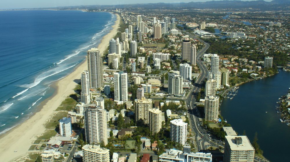
The coast is one long beach broken by headlands: The Spit and the Seaway, Surfers Paradise and the view from SkyPoint, Burleigh Heads, Currumbin, Snapper Rocks and Point Danger on the border with New South Wales. The guide tells the story of each one as you reach it, with where to park and where it is safe to swim.
Behind the coast the hinterland climbs into rainforest: the galleries and waterfalls of Tamborine Mountain, the Skywalk, the lookouts and falls of Springbrook, and the Natural Bridge, where glow-worms light the cave after dark. The theme parks on the M1 have their stories too.
Every place on the map
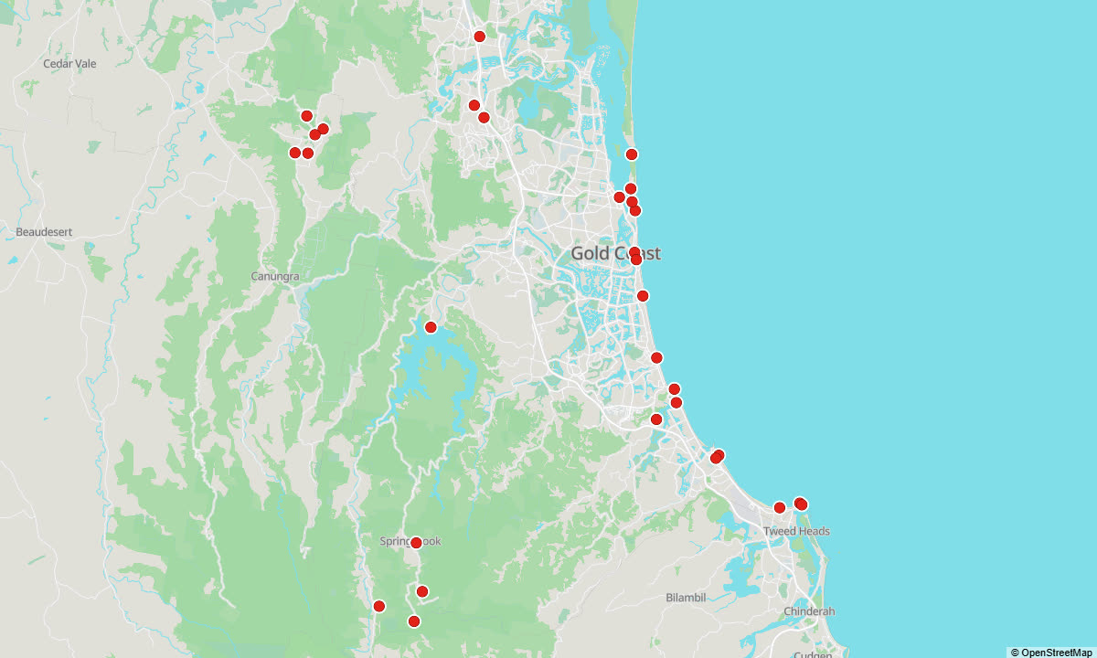
Each red dot is a place with its own story. The story starts by itself when you reach it — on foot, by bike or by car.
All 30 places in this guide
Here is every place the guide tells you about, with the first line of its story:
- Surfers Paradise and Cavill Avenue — Surfers Paradise. Cavill Avenue runs down to the beach here, in the heart of the Gold Coast, and Surfers Paradise itself grew out of a single hotel on this street.
- SkyPoint Observation Deck, Q1 — SkyPoint, the observation deck at the top of Q1. The tower was finished in 2005: seventy-eight floors, and three hundred and twenty-two and a half metres to the tip of its spire.
- Main Beach and Tedder Avenue — Main Beach. North of Surfers Paradise, past the narrow strip of land at Narrowneck, the towers thin out and the coast grows quieter.
- The Spit, Federation Walk and the Seaway — The Spit. Seaworld Drive runs north here along a tongue of sand, with the surf on one side and the calm Broadwater on the other, to the Gold Coast Seaway.
- Sea World — The marine park on The Spit began as a water-ski show.
- Mariners Cove - the whale-watching boats — Mariners Cove. This small marina on the Broadwater side of Seaworld Drive has long been where visitors to the Gold Coast set out on the water: whale-watching cruises in the season, from late May to early November, jet-ski tours, and…
- Broadwater Parklands, Southport — Before there was a Gold Coast, there was Southport.
- Warner Bros. Movie World — Australia's only film-themed park grew out of a real film studio, and the studio is still working next door.
- Wet'n'Wild Gold Coast — This water park opened on the thirtieth of September 1984 under another name, Cades County Waterpark, and it opened with the first wave pool in Australia.
- Dreamworld — The Gold Coast's first big theme park was one man's dream, dug out of the bush at Coomera.
- Broadbeach, Kurrawa Beach and The Star — Broadbeach. This is where the Gold Coast comes for an evening out: the casino, the shops, and streets full of restaurants between the towers and the sand.
- Miami headland and Nobby Beach — Miami. Two small hills break the long run of sand here, North Nobby and South Nobby, and like Burleigh Heads they are the remains of ancient lava flows from the old Mount Warning volcano.
- Burleigh Heads and Jellurgal — Burleigh Heads. The green headland at the south end of the beach is a national park, a sacred place and one of the most famous waves in Australia, all at once.
- David Fleay Wildlife Park — This quiet bush park at West Burleigh was founded by one of the great characters of Australian wildlife, and Queensland's national park rangers still run it in his spirit.
- Tallebudgera Creek — Here the creek meets the sea on the south side of Burleigh headland, and for generations it has been the Gold Coast's family swimming spot: calm, clear tidal water instead of surf.
- Currumbin and Currumbin Rock — Currumbin. The great rock on this beach is Elephant Rock. The first settlers called it Green Rock, for the vines and flowers that covered it, but in old photographs it looks like an elephant sitting on the sand facing the sea, and that…
- Currumbin Wildlife Sanctuary — It all began with a flower grower who was losing his flowers.
- Kirra Beach — Kirra. For surfers, this small rocky point is one of the great names in the world.
- Coolangatta and Snapper Rocks — Snapper Rocks. These low rocks at the southern end of Rainbow Bay, just below Point Danger, are where one of the most famous waves on earth begins: the Superbank.
- Point Danger and the border — Point Danger. On this headland Queensland ends and New South Wales begins, and the lighthouse stands right on the border.
- Purling Brook Falls — Purling Brook drops more than a hundred metres off the edge of the Springbrook plateau into a deep rainforest gorge, and after rain it is a thunderous sight.
- Best of All Lookout — At the southern edge of the Springbrook plateau, almost a thousand metres up, the land ends in a line of cliffs, and the lookout stands right on the state border, looking down into New South Wales.
- Canyon Lookout, Springbrook — Canyon Lookout. This is the easiest view on the Springbrook plateau: you step out of the car and you are there.
- Natural Bridge — In the Numinbah Valley, under the western cliffs of Springbrook, Cave Creek plunges through a hole in the roof of a cave into a dark pool.
- Gallery Walk, Tamborine Mountain — This is Long Road, the way into Eagle Heights, lined with galleries, craft and gift shops, antiques, fudge, cafés and restaurants, and it is the busiest street on the mountain.
- Curtis Falls — In the Joalah section of Tamborine National Park, Cedar Creek pours over a wall of dark basalt into a rock pool, and a short walk from the car takes you down to it.
- Tamborine Rainforest Skywalk — Here you walk through the rainforest canopy instead of under it.
- Cedar Creek Estate — A winery at North Tamborine with a cellar door, a café looking out over the grounds and the lake, a little wedding chapel, and something you will not find at other wineries: a glow-worm cave built by hand.
- Witches Falls — This patch of forest on the western edge of Tamborine Mountain is where national parks in Queensland began.
- Hinze Dam — The lake behind this wall, Advancetown Lake, is the Gold Coast's main supply of drinking water.
Between the places: podcasts
The guide does not fall silent between the places. In the gaps it plays podcasts about Australia — more than 7 hours in this guide: the history of the city and the country, the people, the animals and nature, and life in Australia today. You can listen to them on their own too, before the trip or on the way.
Get the full guide
Access is sold by time, not by tour. One pass opens every guide we have — Sydney, the Sydney Light Rail, the Blue Mountains, the Hunter Valley, Melbourne, the City Circle tram, the Great Ocean Road, the Dandenongs with the Yarra Valley, Cairns with the Daintree and the Gold Coast — in English and in Russian. The time starts when you first open your link.
↓ Tap a price to pay — every pass opens every guide
Secure payment via Square • card, Apple Pay and Google Pay
Free without signing up: the map, 5 places and 5 minutes of the podcast. The full audio unlocks from A$35.
Runs in the browser of your phone, nothing to install. For playing with the screen off there is the app: App Store · Google Play.
Other guides
By Andrew Sorokin, Sydney guide since 2006.